Shropshire flood alerts remain in place as more rain forecast
Rain continued to fall on Shropshire and Mid Wales today making driving treacherous and river levels rise further.
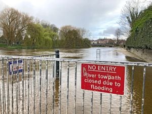
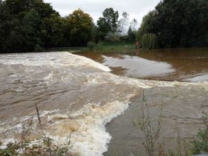
Hundreds of acres of farmland are underwater and the barriers on the River Severn remain up in Shrewsbury, with Frankwell Car Park closed.
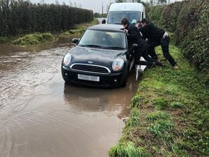
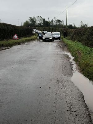
Police have warned motorists of floods and surface water affecting scores of roads across the region. Roads are completely under water in the Melverley are and there are also problems in areas including the A49 at Onibury, the Telford to Tenbury Wells road, and roads around Nesscliffe and Ellesmere.
Powys Highways said that the A490 Welshpool airport road was closed due to flooding.
The Environment Agency said the rivers could continue rising until tomorrow when there is a dry weather window although the peak is not expected to reach Shrewsbury until Wednesday afternoon.
There are two flood alerts in Shropshire, on the River Vyrnwy at Maesbrook and Melverley and one over the north Wales border on the River Dee south of Llangollen.
Lesser flood warnings are in place for the length of the River Severn in Shropshire, the Upper Severn and Vyrnwy in mid Wales and on the Cound and Rea brooks and the Rivers Tern and Perry.
The environment agency said: Flooding is affecting low lying land and roads adjacent to the river from Shrewsbury to Upper Arley. Other locations that may be affected include Coalbrookdale, Ironbridge and Bridgnorth. Please avoid using low lying footpaths near local watercourses."
See also:
Elsewhere, Flash flooding is causing more problems for travellers on the roads and railways as further torrential thunderstorms are set to add to the misery.
Train services in the north of England continued to be badly affected as firefighters across the region warned of the dangers of driving through floodwater after a series of rescues.
But the Met Office said areas further south are likely to be worse affected later on Tuesday as a band of severe thunderstorms sweeps across England and Wales.
Some areas are expected to receive the equivalent of two weeks worth of rain in less than an hour.
And forecasters say that a brief respite from the deluge on Wednesday will give way to even more heavy rain and wind later in the week when the remnants of Hurricane Lorenzo work their way across the UK.
The Met Office has issued a yellow weather warning for Wales, southern England, East Anglia and the Midlands between 6am and 8pm on Tuesday.
It warns of heavy showers and disruption caused by flooding.
Meteorologists have said the slow moving clouds on Tuesday could bring rainfall totals of as much as 40 to 50mm in a couple of hours in some places.
Met Office spokesman Grahame Madge said: “This could lead to the potential for flash flooding quite quickly.”
Mr Madge said the heavy downpours will die out tonight when a ridge of high pressure will see plummeting temperatures with the potential for a grass frost in some areas of the north.
But he said that a day of fine weather on Wednesday will then give way to further wind and rain as what is left of Hurricane Lorenzo – the huge storm currently threatening The Azores – lashes the UK from later on Thursday.
These new storms come as large parts of the north of England and Midlands continue to deal with flash flooding from the heavy rain of the last few days.
At 10.30am on Tuesday there were 70 flood warnings and 184 flood alerts in force.
Northern Rail said the Maryport to Carlisle line was badly affected with replacement bus services operating in some sections.
It said the line is also blocked between Hexham and Carlisle following a reported landslip at Wetherall.
There has also been flooding at Thackley, between Leeds and Carlisle, and services have been suspended between Stockport and Macclesfield due to problems with lineside equipment.
A spokesman said: “Heavy rain and flooding is, again, impacting Northern’s ability to operate services this morning.
“Delays and short notice cancellations are likely across the region as rain continues to fall on already soaked ground.”
The flash flooding was chronicled on social media along with warning from the emergency services.
One Carlisle fire station said on Twitter: “Numerous water related incidents this morning, including cars stuck in flood water, and flooded properties. Please do not drive through flood water, it is not worth the risk.”
An adult and a child was rescued from a trapped vehicle caught in floodwater in Bretby, near Burton upon Trent, at around 8pm on Monday and another water rescue by firefighters took place on Cattal Moor Lane, near York.

Photographs taken at the Ship Inn pub in Mevagissey, Cornwall, on Monday night show floodwater inside the pub and nearby roads submerged.
In the South West, the Environment Agency told people to avoid the seafront and check flood warnings due to forecast high tides and winds.
On Tuesday it said predicted heavy showers could bring a “small chance of fast-flowing or deep floodwater causing danger to life”.