Shropshire crime maps pinpoint hotspots for offences
[gallery] Anti-social behaviour has been highlighted as the scourge of town centres across Shropshire and Mid Wales on a new-look police website.
Anti-social behaviour has been highlighted as the scourge of town centres across Shropshire and Mid Wales on a new-look police website.
The crime-mapping website www.police.uk has been extended to show crimes which happen near 'hotspots' such as nightclubs, parks and shopping areas.
By May, it is intended that the site will also show what happened to offenders, including whether anyone was arrested, charged or sent to prison.
Of the 1,195 crimes recorded in Shrewsbury, Telford, Oswestry, Ludlow, Market Drayton, Bridgnorth and Welshpool in December 2011, 503 – 42 per cent – were complaints of anti-social behaviour.
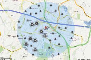
Click on the image to the right to see the town crime maps
Police spokesman Chris Ammonds said the new detail helped put crime figures into context.
He said: "For example, a street might show a high number of crimes, but the figure would be more meaningful if the site also showed that there were a lot of shops on that street which had reported shoplifting offences.
"It's an acknowledgement that there are certain things that will always attract more crime, so it's a more realistic picture."
He said anti-social behaviour would generally be expected to be higher in areas where people gather in numbers, or near pubs and nightclubs.
In Shropshire, Shrewsbury had the most recorded crime with 328 offences, of which 148 were anti-social behaviour.
Castle Gates is highlighted as a hotspot for anti-social behaviour, with 10 recorded offences, and there were four violent crimes near the bus stops in Barker Street.
In Telford town centre, anti-social behaviour accounted for 98 of the 297 recorded offences. Shoplifting was the next highest problem with 51 reports.
The map shows that offences in the TF3 area are concentrated around the shopping centre, with small clusters close to the nightclubs and pubs.
Crime is spread quite evenly across Ludlow town centre, although there was a cluster of anti-social behaviour complaints on or near the Bull Ring and three violent crimes were recorded on High Street.
Violent crime was a particular problem in Oswestry in December, with 18 per cent of the 194 offences recorded in that category - including four in or around New Street.
Anti-social behaviour still accounted for more than half the crimes, with 102 reported.
Northgate and High Street proved to be the crime hotspot in Bridgnorth, with all but four of the 17 offences committed in the area classed as anti-social behaviour.
Just over 40 per cent of crimes in Market Drayton were deemed anti-social behaviour, particularly inside the ring road, but the town had the lowest percentage of violent crime.
Welshpool bucked the trend, with criminal damage proving the biggest problem in the Mid Wales town. There were 12 incidents of criminal damage or arson recorded in or near Westwood Park alone.
Home Secretary Theresa May said the Government was giving the public more information than ever before about crime and policing in their areas through street-level crime maps.
"Since October the public have been able to use the police.uk website to see how their force performs in a range of areas like crime rates, quality of service and victim satisfaction," she said.
"Today we'll launch the next stage of crime mapping, in which we'll start to map crimes to or near a range of public places like railway stations, nightclubs, parks and shopping areas.
"By May, crime maps will show the public what happens after a crime has occurred - what action the police took and what the criminal justice outcome was.
"You'll be able to see if the criminal was arrested, charged and sent to prison."
Police.uk received more hits than any other Government website last year.
By Ann Clarkson