
Wilfred Owen: Mapping war poet’s early life at Shrewsbury museum
A huge map detailing the life of one of the First World War’s most famous poets has been unveiled in Shrewsbury.
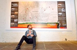
The Wilfred Owen 100 map has been installed in the shut at Shrewsbury Museum & Art Gallery and is proving to be a big hit.
It is a reproduction of a second edition Ordnance Survey map from 1902 and shows pre-First World War Shrewsbury, which would have been familiar to the poet.
The map shows the town changing rapidly with expanding suburbs such as Cherry Orchard. The young Wilfred Owen first lived in Canon Street with his family and this is shown on the map although his longer term home on Monkmoor Road has not yet been built.
Also illustrated are St Julian’s Church, Wyle Cop School, the Technical College on Abbey Foregate, and Uffington where the Owen family used to worship. The map also offers insights in to the town before mass slum clearances took place in the 1930s.
Also shown is the enlargement of the railway station - the station that the young man departed from for the Front before he died in 1918 at the age of 25.
The shut which houses the map would have been an entrance passageway through some shops fronting the Square to the courtyard of Vaughan’s Mansion, which now forms part of the Museum & Art Gallery complex.
By the 19th century the shut was known as Fire Office Passage and later still it became Music Hall Passage.
The map forms part of the Wilfred Owen 100 commemorations being held in Shropshire to mark the end of the Great War