Flashback to 2006: Huge project to keep Ironbridge Gorge ‘still’
For residents living in parts of the Ironbridge Gorge, land movement has been a fact of life.
It has gone on for centuries. Generally it has been a slow process, with tell-tale signs like a building at a strange angle here and there, and buckled and distorted roads.
Very occasionally there have been more dramatic events – landslides.
Factors at work are the geology of the Ironbridge Gorge, erosion, and mining in the area in the past.
The area has so many classic land instability features that it has been used for field trips by geotechnical students. Basically parts of the Gorge are slipping towards the River Severn.
It is against this backdrop that in September 2006 the first part began of a massive scheme to stabilise land in the Ironbridge Gorge, which is a World Heritage Site.
At the time the ground in the targeted area had already shifted so much it had broken monitoring equipment designed to measure the speed of movement.
Engineers found that the main slide was slipping around 150mm a year, but there was a small section moving much faster, at around 500mm (about 20 inches) a year which, when you're talking about rates of land movement, is a big deal.
Initially it was a £20 million project with the aim of stabilising The Lloyds, on the north bank of the River Severn. Work began just a few days after Telford & Wrekin Council won more than £3 million in funding.
Amec Piling was awarded the contract to carry out the work which would see 140 huge piles sunk, surrounded by tonnes of concrete.
Three rows of 750mm diameter reinforced concrete tubes were installed 30 metres into the ground. Voids in the ground also had to be filled.
As they worked, the engineers had to be careful not to have too much heavy equipment in one place, in case it triggered a landslide. They also had a consultant to advise on local environmental issues.
The work was completed in August 2007, and according to the engineers involved, will be effective for about 30 years or so.
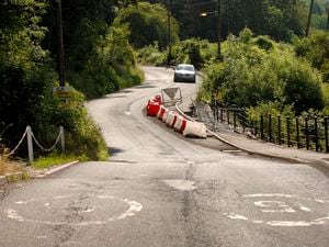
And this was just the start. There were to be further phases of work in the Lloyds area, and then in 2014 attention moved over the river to Jackfield, one of the worst affected areas, with things so bad that it had a flexible "wooden road."
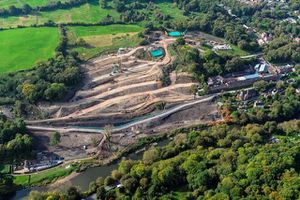
The contract for the main phase of the project there was awarded to McPhillips (Wellington) Ltd and the work was completed in October 2016.
The stabilisation project primarily involved the sinking of over 2,000 concrete piles of 600mm diameter, reinforced with 450mm diameter steel tubes of up to 13 metres long, and the installation of over 500 concrete piles of 250mm diameter, reinforced with 139mm steel tubes, again up to 13m long.
There was also extensive landscaping, transforming the area.
By 2016 Telford & Wrekin Council had spent over £33 million on land stabilisation, but reckoned it needed £60 million more to fund the continuing programme.
One major historic event to focus minds came in 1773 when there was an enormous landslip between Coalbrookdale and Buildwas which blocked the River Severn.
Something similar happening again is a nightmare worst-case scenario, which as well as the landslide damage could cause flooding as far upstream as Atcham.
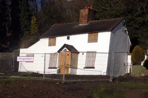
There have been some relatively minor incidents in recent times which have propelled the problem into the headlines, as well as the evidence of the continued gradual movement leading to things like cracks in buildings.
The major event of living memory was the landslip in Jackfield in 1952 which led to homes being lost and part of the community having to be rehoused permanently.
Estimates vary, but it seems around 16 properties including the village post office were lost over several months.
And in the early 1980s Salthouse Road slipped a distance of about 20 metres toward the river over a period of a few weeks.
Telford & Wrekin Council has a process of continuing monitoring of areas of greatest risk, and has drawn up just-in-case emergency plans.
In a special information pack for residents in the Gorge, it says that typically major events happen at intervals of 30 to 50 years.
"The long-term aim must be to manage the risk of instability and help to stabilise the area.
"While it is not possible to stop ground movement completely within the Ironbridge Gorge – the forces of nature are far too powerful –it is possible through various engineering works to minimise movement."