Future fears for Shropshire's historic past
It is a risk that continues to grow – 98 Shropshire historic sites that are now considered under threat.
In the last year 13 sites have been added to the list, which is compiled by Historic England.
It's not all bad news, with 11 Shropshire sites also being removed from the register. But there is still plenty to be concerned about – scores of building that are slowly, but surely, fading away before our eyes.
Among those added to this year's list is Grade II listed Trinity Hospital in Clun, which was founded in 1607 by Henry Howard. English Heritage says the building complex is in "a very poor condition" and some sections have collapsed, with no solution to the upkeep yet agreed.
The Church of St Chad in Shrewsbury has also been placed on to the list although churchwarden David Tudor says the status is a mixed blessing, having paved the way for funding applications to fix problems with the nave balustrade.
A grant of £220,000 has been secured from the Heritage Lottery Fund. The church also has another £80,000 of funding towards the project, with £40,000 from the fundraising activities carried out by the Friends of St Chad's and another £40,000 from the Listed Places of Worship Grant Scheme.
Mr Tudor said: "Water has been getting down in to the sandstone of the cornice on the nave. The stone is very porous and the water has corroded some of the iron pins inside. In other words the blocks are not held together as firmly. That work needs to be done urgently to secure the stonework."
In south Shropshire the 12th century Church of St Mary in Ashford Carbonel, Church of St John the Baptist in Nash, Church of St Mary in Bitterley, and the Church of St Catherine in Tugford have all been placed on the list, along with the parish church at Boraston and the Church of St Michael and All Angels at Smethcott.
In Shrewsbury the Church of the Holy Trinity at Minsterley and the Church of St Lucia in Upton Magna are also deemed to be at risk.
Wat's Dyke close to Preeshenlle Lane and St Martin's Road in Selattyn Gobowen has also been identified as having minor localised problems as has the ringwork and bailey castle close to Lyndale, Westbury. The red castle in Hawkstone Park, Weston under Redcastle is described as experiencing significant problems, but work to remedy these has started.
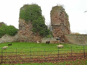
Alberbury Castle and Wattlesborough Castle, the latter built in the 13th century by Sir Robert Corbet, are also deemed to be at risk. Wattlesborough is a time capsule where design features dating to the 14th, 16th and 17th centuries can still be seen, from the windows to the fireplaces. On the register since 1998, the ruins have been exposed to the elements and parts of the masonry are crumbling away.
One major Grade I Shropshire building which has remained on the list for a number of years is the Ditherington Flaxmill in Shrewsbury. The building is the subject of a long-term regeneration project and although efforts have stalled, the Friends of the Flaxmill Maltings are set to open a visitor centre next month.
Councillor Alan Mosley, chairman of the friends group, said: "I think it has been on the register ever since English Heritage took it over in 2005. They have done a wonderful job of protecting the fabric of the building to stop it getting any worse and making investment where possible."
Parts of our heritage at risk of crumbling:
The Historic England list is as follows:
Trinity Hospital, Hospital Lane, Clun
Church of St Chad, St Chads Terrace, Shrewsbury
Church of St Mary, Ashford Carbonel
Church of St Mary, Bitterley
Church of the Holy Trinity, Minsterley
Church of St John the Baptist, Nash
Church of St Catherine, Tugford
Church of St Lucia, Upton Magna
Parish Church, Boraston
Church of St Michael and All Angels, Smethcott
Wat's Dyke, 420m long section, 190m west of the junction between Preeshenlle Lane and St Martin's Road, Selattyn and Gobowen
Ringwork and bailey castle 350m south west of Lyndale, Westbury
Red Castle: an enclosure castle in Hawkstone Park, Weston-under-Redcastle
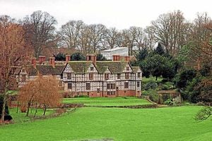
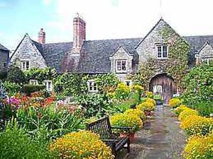
Pitchford Hall, Pitchford
Former Ditherington Flax Mill and attached former malt kiln, flax dressing building and flax warehouse, Spring Gardens, Ditherington, Shrewsbury
Barn to west of Hall Farmhouse, Aston Eyre
48 Mill Street, Bridgnorth
Rockley Farmhouse, Chirbury with Brompton
Trinity Hospital, Hospital Lane, Clun
Old Hall and attached garden wall, Old Marton, Ellesmere Rural
Pentre Isaf, Oswestry
Brogyntyn Hall, Brogyntyn Park, Selattyn and Gobowen
Apprentice House of former Ditherington Flax Mill, Spring Gardens, Ditherington, Shrewsbury
Stove House and Dye House at former Ditherington Flax Mill, Spring Gardens, Ditherington, Shrewsbury
Pell Wall Hall, Newport Road, Sutton upon Tern
Hawkstone Windmill, Hawkstone Park, Weston-under-Redcastle
The Old Rectory, Claypit Street, Whitchurch Urban
Cheney Longville Castle, Cheney Longville, Wistanstow
Hargreaves Farmhouse, Winnington, Wollaston
Heath Chapel, Stoke St Milborough, Heath
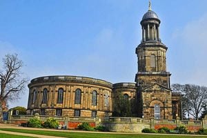
Abbey Church of the Holy Cross, Abbey Foregate, Shrewsbury
Church of St Chad, St Chads Terrace, Shrewsbury
Church of St Peter, Wrockwardine
Church of St Mary, Ashford Carbonel
Church of St Mary, Bitterley
Church of St John the Baptist, Kenley
Church of the Holy Trinity, Minsterley
Church of St John the Baptist, Myndtown
Church of St John the Baptist, Nash
Church of St Catherine, Tugford
Church of St Lucia, Upton Magna
Parish Church, Boraston
Church of St Mary the Virgin, Salthouse Road, Jackfield
Church of St Peter, Church Road, Oakengates
Church of St Michael and All Angels, Smethcott
Alberbury Castle, Alberbury, Alberbury with Cardeston
Wattlesborough Castle (uninhabited parts), Alberbury with Cardeston
Ludlow town walls, Ludlow
Remains of Lea Castle at Lower Lea Farm, Lea, Lydham
Charlcotte Furnace, Neenton
Nag's Head engine house, Pontesbury
Town walls, Shrewsbury
Bedlam Furnace, The Gorge
Red Castle, Hawkstone Park, Weston-under-Redcastle
Candle House, Snailbeach Lead Mine, Worthen with Shelve
Snailbeach New Smeltmill, Worthen with Shelve
Charlton Castle, Wrockwardine
Little Shrawardine motte and bailey castle, Alberbury with Cardeston
Ringwork 540 metres north of Lane Farm, Alberbury with Cardeston
Stanwardine moated site and associated fishpond, Baschurch
Lower Cleeton moat, a moat and fishponds 380 metres south east of Cleeton Court, Bitterley
White Ladies (St Leonard's) Priory, Boscobel
Bowl barrow 450 metres north west of Felton Farm, Bromfield
Roman camp north of Bromfield Farm, Bromfield
Castle Tump, a motte castle and causeway, 150 metres west of Teme Bridge, Burford
Enclosed Iron Age farmstead immediately adjacent to The Croft, Pave Lane, Chetwynd Aston and Woodcote
Motte and bailey castle 150 metres north east of Wilmington, Chirbury with Brompton
Offa's Dyke: section 2/3 mile (1170 metres) long, north from southern boundary of Rownal Covert, Chirbury with Brompton
Offa's Dyke: section one mile 750 yards (2290 metres) from Dudston Covert to a point 300 yards (274 metres) north of Lack Brook – Also in Powys: Wales, Chirbury with Brompton
Offa's Dyke: two sections running 400 yards (370 metres) south of Camlad Stream – Also in Powys: Wales, Chirbury with Brompton
Motte castle 80 metres north east of Home Farm, Church Stretton
Bowl barrow 390 metres south east of Stanley Cottage, Clunbury
Norton Camp: a large multivallate hillfort, Culmington / Craven Arms
The Mount motte and bailey castle, 120 metres north east of Hill House Farm, Diddlebury Moated site and associated ridge Magdalene's Church, Hadnall
Roman villa north east of Cottage Coppice, Harley / Much Wenlock
Roman camp on Red Hill, Lilleshall and Donnington
Offa's Dyke: section 890 metres north west and 320 metres west of Little Selley, Llanfair Waterdine
Offa's Dyke: section 90 metres south of Brynorgan, Llanfair Waterdine
Motte and bailey castle 100 metres west of Holy Trinity Church, Lydham
Nickless moat, Milson
Callow Hill Camp: a small multivallate hillfort, Minsterley
Roman villa at Linley Hall, More
Offa's Dyke: section 175 metres east of Cefn Bronydd, Newcastle on Clun
Small enclosed settlement on Fron, 340 metres west of St John's Church, Newcastle on Clun
Offa's Dyke: section 400 metres south west of Springhill Farm, Newcastle on Clun / Clun / Llanfair Waterdine
St Leonard's Priory immediately adjacent to the Church of St Mary and St Leonard, Wombridge, Oakengates
Roman villa 150 yards (140 metres) south east of Lea Hall, Pontesbury
Canal aqueduct over River Tern, Rodington
Wat's Dyke, 420m long section, 190m west of the junction between Preeshenlle Lane and St Martin's Road, Selattyn and Gobowen
Roman camps south west of Stoneyford Cottages, Shifnal
Uxacona Roman site (See also Shropshire Unitary Authority), Shifnal / St Georges and Priorslee/Lilleshall and Donnington
Uxacona Roman site (see also Telford and Wrekin Unitary Authority), Shifnal / St Georges and Priorslee / Lilleshall and Donnington
Site revealed by aerial photography north of Castle Farm, St Georges and Priorslee
Roman military site at Rhyn Park, St. Martin's
Camp Ring motte and bailey castle, enclosure, fishpond and ridge and furrow 400 metres east of Culmington Farm, Stanton Lacy
Churchyard of St James's Church, Stirchley and Brookside
Medieval fishpond reservoir north east Haughton, Uffington / Upton Magna
Robury Ring: a small enclosed settlement on Wentnor Prolley Moor, Wentnor
Hawcocks Mount ringwork castle 200 metres north east of Hawcocks Farm, Westbury
Ringwork and bailey castle 350m south west of Lyndale, Westbury
Red Castle: an enclosure castle in Hawkstone Park, Weston-under-Redcastle Upper Barn moat, Wistanstow
Bowl barrow 120 metres south west of Dorrington Cottage, Pipe Gate, Woore
Bowl barrow at The Napp, Worthen with Shelve
Snailbeach New Smeltmill, 350 metres north east of Green Acres, Worthen with Shelve
Two bowl barrows 290 metres north of Upper House Farm, Worthen with Shelve
Moated site and a fishpond 160 metres and 280 metres south of The Farm, Charlton, Wrockwardine
Clee View, Highley
Llanymynech, Llanymynech and Pant